

Searching for spatial information science that would be useful for
everyone in the future,
the Anagura researchers went to meet six researchers.
everyone in the future,
the Anagura researchers went to meet six researchers.


Researcher A: The device that I brought into Anagura is Nagame [Perspective]. This device can digitize space itself and create a three-dimensional map.
Researcher B: I developed the Ido [Movement] device, which can continue to keep track of people. In order to gain hints for our development, we went to talk with an expert in this field. The following is a record of our conversation.
(At the Center for Spatial Information Science, on a certain day in the year 2011)

- Researcher B
- When I was thinking about the concept of Ido, I heard the expression "spatial information science." Was it you who began to use this term?
- Shibasaki
- Research in this field began back in the 1950s. Some geographers at the University of Washington started to use computers, which were only just appearing then, with the aim of collecting data and displaying the results of analysis on a map. In the 1980s the term "geographic information system" [GIS] appeared and spread in the fields of urban planning and engineering, such as transportation. In the 1990s geographic space of various scales began to be handled, such as buildings, local districts, and national land. The Center for Spatial Information Science was founded at the University of Tokyo in 1998. That was maybe the first time for the term to be officially used in Japan.
- Researcher B
- What would be a simple definition of spatial information science?
- Shibasaki
- Based on position and place, it is a technology for closely linking real space and information space and enabling the effective use of necessary information in real space. For this purpose, first of all it is necessary to monitor the targeted people and objects and gather data. Next it is necessary to integrate and analyze the information and understand what is happening and where at this very moment. Then it is necessary to visualize the information, for example by displaying it on a map, transmit it in an easy-to-understand manner, and offer advice in anticipation of what may happen next. Spatial information science seeks to support the solution of various problems that occur in the real world.

- Researcher A
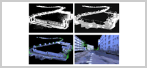
- I see. Nagame, the device that I developed, monitors space and creates a digital space map, so it can be described as a device that helps realize spatial information science, can't it? How far has this technology for digital mapping progressed?
- Shibasaki
- The technology for creating three-dimensional maps of objects that do not move, such as buildings and roads, is just about entering the practical stage. The research problem at the moment is how to create a perfect map automatically just by sending out a vehicle carrying various sensors. The key point here is how much the level of automation can be raised. Furthermore, since it is now possible to monitor moving objects, such as pedestrians and cars, we are shifting to research on how to display this moving data on maps and understand congested places and flows. Research has gone as far as being able to guess whether the person on the pavement is a man or woman, speculate that the person might be lost, because he or she is looking around, and so on.
- Researcher A
- On the basis of the map created by Nagame, it will be important to integrate moving information about people and objects existing in that place, such as information from Ido, won't it?

- Researcher B
- Ido is a device for following people and displaying their tracks. What are the research themes in this technological domain?
- Shibasaki
- In order to accurately track people, for example, research is being conducted on how to complement information using the limitations and knowledge of people walking. If we could understand certain patterns in walking and use them, we would be able to fill in the data holes for places that cannot be monitored, such as inside tunnels, and we would be able to eliminate as noise those incredible moments in tracks where, for instance, a person appears to have suddenly jumped 10 meters.
- Researcher B
- That would be good! I'd like to use that in Ido.
- Shibasaki
- By combining knowledge relating to people's behavior and monitored data, we can obtain even deeper information. For example, if someone is always following the same person, there is a possibility that he or she is a stalker. Or if the surface temperature of a person's face rises when he is approached by a security guard, then that person might be feeling guilty about something. If we could combine an infrared sensor and a position sensor, we would be able to identify and continually mark a suspicious person.

- Researcher B
- So spatial information science is especially effective for security?
- Shibasaki
- Spatial information science is going to be used not only in the limited field of security but also in everyday scenes targeting many more people. For example, if we use wide-area tracking data using the global positioning system [GPS], we can control and guide the flow of many people. When the trains stop for some reason, the station overflows with people, and long queues wait for the alternative buses. If information about such a situation could be shared with restaurants and stores in the vicinity of the station, drinking places could offer special services for the stranded people. If there is no need for people to get home quickly, they could visit these places and bide their time there. It would be possible to disperse people in a calmer manner. People could share taxis. From their records of behavioral data, it would be possible to see where people are going and to put those going in the same direction together, thus making it easier for them to cooperate.
- Researcher A
- In other words, by sharing information, new cooperative relations are born.
- Shibasaki
- That's right. For example, it's a form of cooperation if, when there is a traffic jam, people go different ways rather than concentrating on one detour route. If a disaster victim were feeling unwell and unable to escape, even a stranger could go and help if they knew the place. If people know what is happening and where at this very moment, then cooperation expands, doesn't it? At present people still keep information to themselves, but information is definitely not going to dry up. If we share it, we can make new discoveries. Information really is the biggest asset of humankind.

- Researcher A
- Why do people keep information to themselves?
- Shibasaki
- One of the reasons is that people are worried because they don't know how information they release is going to be used. They think that if they release information, others will benefit and they will lose out in some way. Another important factor is that an individual's location information is private information. For example, mobile phones are in constant communication with base stations, so information about the whereabouts of the user must be kept in the mobile phone company. But that information falls under the confidentiality of communications, so the data cannot be released outside. At the time of the Great East Japan Earthquake, for example, people who were searching for missing relatives were unable to use this information. The data was there, but it could not be used at all. Something really must be done about this problem.
- Researcher B
- What do you think is the solution to these problems?
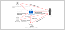
- Shibasaki
- People should essentially be able to manage their personal information themselves and use it for themselves. As a mechanism for this purpose, we are experimenting with the "information bank." The person concerned deposits personal information in his or her account at the information bank, so that it is used only for that person. At the time of a disaster, though, when rescue teams want to know how many people remain and where, the information bank tells them how many people there are while ensuring there is no leakage of private data. If the information bank, like a bank that handles money, can definitely protect the information deposited by individuals, and if that information at the same time can contribute to society in various ways, then the sharing and utilization of information is sure to advance.

- Researcher A
- If the information bank permeates society, thinking about personal information will change a lot too, won't it? Finally, what kind of society are you ultimately aiming for?
- Shibasaki
- Regarding social problems, even if new technologies are churned out one after the other, it's going to be hard getting people to use them. For example, super-high-performance wheelchairs might be distributed to support the mobility of elderly people with weak legs and backs, but it's not very likely that they will use them to go shopping even if the wheelchairs do drive automatically along the roads. It's just not going to happen. But if a person in the vicinity happens to be going in that direction and gives them a ride in his car, they will go shopping together. That would be much better. If we share information about "what and where" and help one another, we can do various things. If solving problems with new and advanced technologies can be described as "winning after a battle," then this approach is "winning without a battle." That will be the strategy of the "the Art of War."
- Researcher B
- The image of information technology looks like it is going to change too.
- Shibasaki
- Until now the image of information technology has been, if anything, a closed one. People just stare at their computer screens and don't pay any attention to others around them. But people have begun to think that there is something weird in this. Rather than the information inside the computer, maybe the old lady nearby actually knows a good deal more. Maybe it would be much more interesting to visit her and listen to what she has to tell. After all, the main actors are people. It is just necessary to help and direct the linkage between people, and that's where spatial information science comes in.
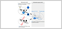
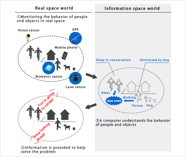 The Idea of Spatial Information Science
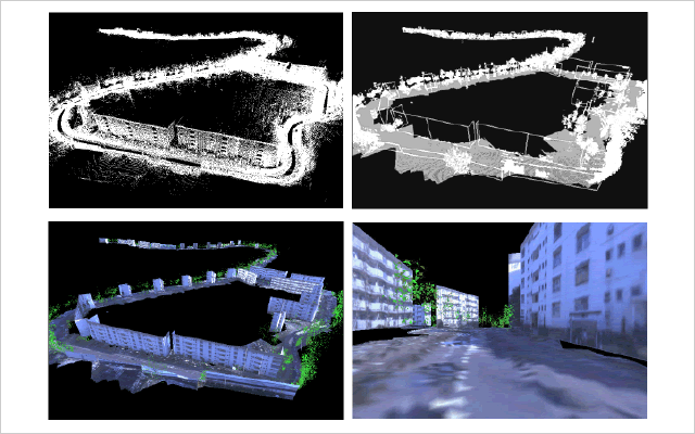 Three-Dimensional Map Created Automatically
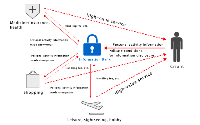 Image of the Information Bank
Ryosuke Shibasaki
Professor, Center for Spatial Information Science
University of Tokyo
Shibasaki Laboratory,
Center for Spatial Information Science, University of Tokyo
http://shiba.iis.u-tokyo.ac.jp/
University of Tokyo
Shibasaki Laboratory,
Center for Spatial Information Science, University of Tokyo
http://shiba.iis.u-tokyo.ac.jp/
 Page top